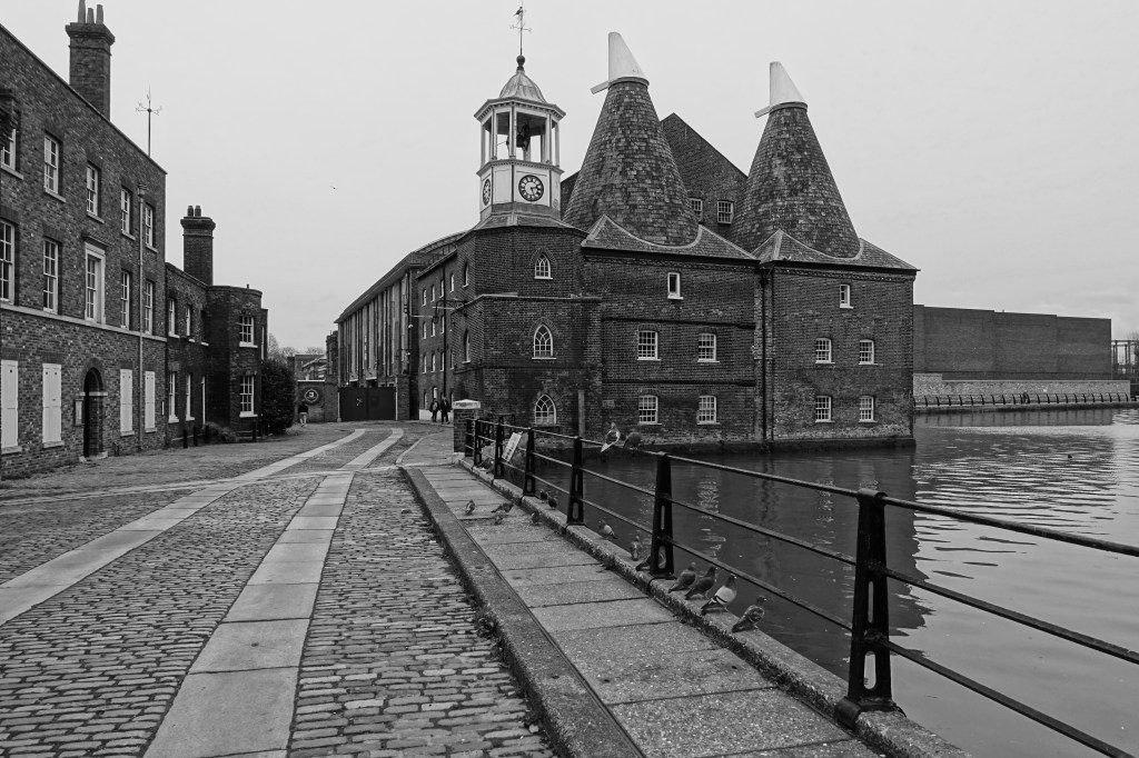
Three Mills, shit and sugar – A lovely walk.

Having set myself a task of walking the 78 miles of the Capital Ring walk around London over the next year and setting my start point at Hackney Wick I decide it would be a good idea initially to do a walk around the area of the Olympic Park area. I wanted to explore some of the history and industrial heritage of the area. A good precursor for the start of the walk.

The walk of 3 miles started at Pudding Mill lane and followed some of the Greenway running through this part of London. The weather was dry but it had got colder than it had been recently.

Docklands Light Railway.

Due to engineering works we had to get the train into Liverpool Street, then tube to Bank where we got onto the DLR to Pudding Mill Lane, the start of the walk.

Starting off on a North West direction under the railway we found a great cafe at the Olympic Park and started the day with a bacon bagel and coffee.

Olympic Park

From there we followed the Greenway and Victoria Walk North West as far as the crossing of the Lea Navigation.

The Greenway, formerly known as Sewerbank, is following the course of the Northern Outfall Sewer which is part of the London sewage work carried out by Joseph Bazalgette.

Bazalgette built London’s first sewer network in the 19th Century and was responsible for wiping out Cholera in the capital. The sewers took 16 years to build and are still in use today.

Alongside the River Lea.

Going down on the track to the left before the bridge over the Lea we then took a course South alongside the River Lea Navigation. At this point the sewer crosses the river overhead in an enormous steel construction.

The steel construction which supports the main Northern outfall sewage pipes over the River Lea.

The path was dry and there much to see with boats along the river.

There are many colourful and interesting narrowboats along the canal.

An interesting building across the others side of the river is the Bow Quarter which is the old Bryant and May match factory, redeveloped in the 1980s it is now flats and town houses.

Just before the Bow flyover we had to jiggle round the river at the point where the river splits to travel North East and becomes St Thomas Creek.

Crossing over to the other side of the river we go as far as Three Mill Lane where we cross the river again onto Three Mills Island.

There are references to mills on this site in the Domesday survey of 1086 which is considered to be the earliest record of a mill system in England.

The current mills were bought in 1727 by three local Huguenots. It was a good location for mills with the strong tidal flow giving eight hours of power per tide.

The mills are currently film studios with programs such as Masterchef being filmed there.

Continuing North we travel alongside Three Mills Wall River and stop off at Three Mills Green for a late lunch of sandwiches. East of us across the Prescott Chanel, a tributory of the Three Mills Wall River, are the original and new Abbey Mills sewage pumping stations, something we will be visiting on our next walk.

As we continue North we can see to the West of us Sugar House Island. The Island is named after a striking 19th century five-storey red brick warehouse which still stands on site.

As we arrive at the A118 High Street we cross over to continue our walk back in a Westerly direction to the end at our start point at Pudding Mill Lane DLR station. Before continuing though we stop on the A118 to admire the old Yardley box factory and offices.

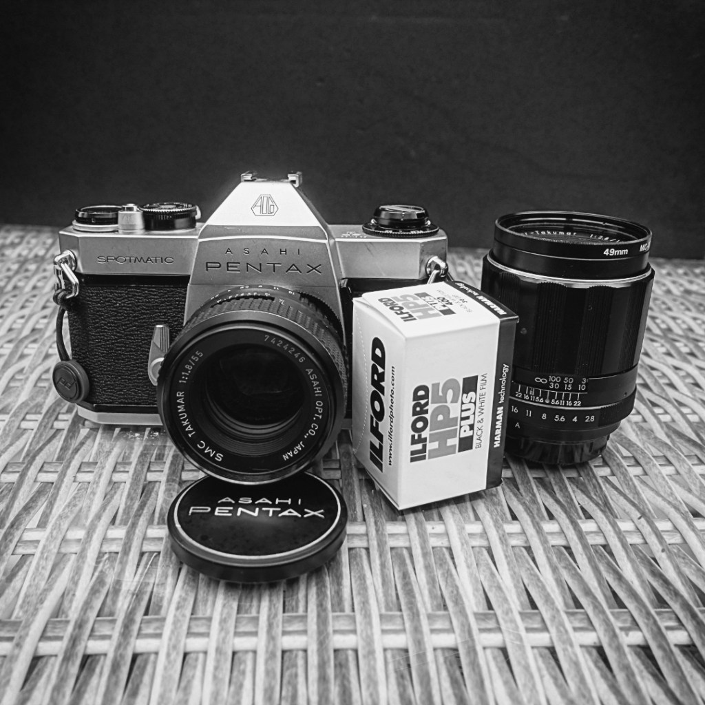
A day at the Fort with the Pentax Spotmatic.

An interesting trip out a while ago with my favourite retro camera of the moment, the Asahi Pentax Spotmatic SPII. We drove up into Suffolk to the end of the promontory where Felixstowe Docks are located. There is an old Fort called Landguard Fort built in the 1500s originally but the present construction dates much later. Being an overcast day and the Fort a very grey concrete construction I thought it would make an ideal subject for black and white film. So, I loaded up with a 36 exp roll of Ilford HP5+ and put a spare in my bag. I took my 55mm f1.8 and my 105mm f2.8 Takumar lenses fitted with a yellow filter for an added bit of contrast.

I love this old camera. It seems to fit my hand so well and I like the weight of it which has a feel of quality. The shutter sound too sounds really great and makes you feel you have an instrument of quality in your hands. The Takumar lenses are brilliant as is the Zeiss 29mm one.

It was a rather grey and overcast day so it was a little difficult in places accommodating the low light levels but all in all I was very pleased with the results.

Wimpole Hall, Cambridgeshire.

Built in 1650, Wimpole Hall is a neo-classical building and is Grade I listed. The estate itself is Grade I listed on the Register of Historic Parks and Gardens.
Owned by the Chicheley family for 250 years the house passed through a number of familys before passing into ownership by The National Trust.
As the National Trust are now opening up access to their properties we were able to book a visit there a few days ago.
I took it as an opportunity to do some photography using one of my 35mm SLR film cameras.

Camera: Olympus OM2n 35mm SLR

Lenses: 35mm f2.8 Zuiko. 50mm f1.4 Zuiko. 135mm f2.8 Zuiko.

Filter: Hoya Orange (G) filter.

Film: Ilford FP4 rated at 125asa. Developed in Ilford ID11 diluted1+1 for 11 minutes @20degC.

Scanned to digital using a Plustek 8100 scanner.

Wimpole Hall.
Wimpole Hall.
Wimpole Hall.
Wimpole Hall.
Wimpole Hall. The rear of the house.
Wimpole Hall. Walking across the parkland at the rear of the house toward the Folly.

The park was “naturalised” by Capability Brown. The North Park is particularly attractive with its belts of woodland, gentle rolling hills with individual trees and clumps of trees. The central feature of the North Park is the Gothic Tower known as The Folly and the restored lakes in the valley below.

The folly is designed to resemble the ruins of a medieval castle. It was built on the grounds of Wimpole Hall in the mid-1770s

The bridge known as the Chinese Bridge.

Single-arch timber bridges were often called ‘Chinese’ in the eighteenth century, probably because they were reminiscent of the bridges shown on Chinese porcelain, lacquer, silk and wallpaper. It was designed by Lancelot Brown and was rebuilt in the mid 20th century.

The lake.
Norfolk Horn sheep.

Wimpole Farm is one of the UK’s largest rare breed centres and they play a key role in conserving rare and traditional breeds of livestock.

The Folly.
Detail of The Folly.
The lake.

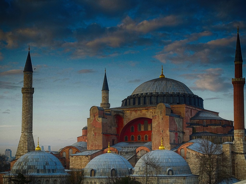
Istanbul Day 1 and 2

Day 1 – March 5th

Each year on my birthday month I tend to go somewhere for a short city break. This year I chose Istanbul in Turkey. It seemed like too good an offer to pass over with 6 nights including flights and transfers from the airport for a little over £400.

The journey from Sabiha Gokcen International Airport, 30 miles South-East of Istanbul, to our hotel in Istanbul took around 1 1/2 hours including our driver getting into a scrap at a busy junction with a yellow cab driver. The timely arrival of a policeman on a motorbike broke up the two characters rolling around on a bonnet of the yellow cab throwing punches at each other. Fortunately the policeman didn’t arrest the cabbies and cart them off so we could continue our journey.

Eminonu where the boats depart along the Bosphorous

With all it’s mix of cultures and the changes throughout the ages to it’s architecture I thought it would be an interesting place to visit, and I wasn’t disappointed.

The area known as the Hippodrome, once a gigantic stadium which stood at the heart of the Byzantine city of Constantinople. It is now an elongated garden and an area where people can promenade.

Istanbul wasn’t at that time showing any cases of the virus but we were scanned at the airport when we arrived by a thermal camera which should show anyone with a temperature.

Across the Hippodrome with the German Fountain. Built to commemorate the visit of the German Emperor Wilhelm II visit.

Formerly known as Byzantium and Constantinople and with over 15 million inhabitants, the city stands in a position between Europe and Asia. The city is split by the Bosphorous Strait which connects the Black Sea with the Sea of Marmara. As the only sea route between the oil-rich Black Sea and the Mediterranean, the Bosphorus is one of the busiest waterways in the world.

Strolling up the street from the Hipodrome to our hotel at the end of the day.

We had a small but very comfortable hotel, The Hotel Perula, just a few minutes walk up a street from the Hipodrome and ideally located for all the tourist attractions.

Located in the Hippodrome is the Egyptian Obelisk which was built in 1500 BC and stood outside Luxor. It was brought to Constantinople by the Emperor Constantine.

We spent the rest of the first day on a short walk around the Hippodrome and the surroundings to get our bearings.

Day 2 – March 6th.

we decided to visit firstly the underground water reservoir called the Basilica Cistern followed by the two local mosques. The Basilica Cistern dates from the reign of Justinian in the 6th century. It consists of a vast underground cavern used to store the water which runs down from the nearby mountains in the vast underground where the roof is held up by 336 columns, each over 8 metres tall.

The inside of the Basilica Cistern.

Following our visit to the Cistern we firstly visited the Haghia Sophia mosque, then Suleymaniye, commonly known as the Blue Mosque.

There were plenty of people posing for shots with the Haghia Sophia in the background.
A selfie on the run!
Another view of the German Fountain.
One of the many cats in Istanbul.
Roasted chestnuts and sweetcorn.
Haghia Sophia mosque.

After wandering round the Hippodrome we vsited the Haghia Sophia mosque. The security here at the entrance is very stringent and I had my mini tripod taken from me. I should have had it in my bag rather than attached to the camera.

Interior of Haghia Sophia.
Interior of Haghia Sophia

The interior of Haghia Sophia was a little disappointing as they are obviously doing some serious refurbishment and there is a lot of scaffolding up but then at over 1,400 years old I guess it’s not surprising.

Our second visit was to Suleymaniye mosque, commonly known as the Blue Mosque.

A view of the blue mosque from the Hippodrome.
Interior of the blue mosque.

Built between 1609 and 1616 the blue mosque is known as such because of it’s blue iznik tiling on the interior. As the Haghia Sophia, this mosque is a little disappointing as it has quite a lot of restoration going on. I think I still managed to get some good shots using my fisheye lens.

Interior of the blue mosque. The amount of scaffolding on the right hand side and the rectangular covering of the columns is a little disappointing.

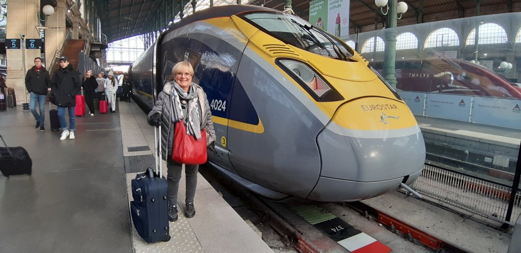
A few days in Provence. Day 1

Day 1 Friday

Up at 5 this morning. Taxi booked for 06:30. A chilly morning. Caught the 06.49 from Bishops Stortford to Tottenham Hale.

Bloody silly ticket doesn’t work. This happens so much these days with the automatic barriers. I got told off by a rail man for just using my body weight to force through one of the barriers.

07:40 and sitting in St Pancras station at a Pret having coffee. Still got nearly 2 hours before we depart.

St Pancras International

12:40 and just arriving in Paris. Reading the news it seems the French rail workers are on strike in some areas. Just hoping it doesn’t affect our journey through Paris to Gare de Lyon for our onward journey.

Paris Gare du nord.
Paris gare du nord

Disembarked Eurostar and found our way to line D metro in the direction of Melun. It would seem that the strikes have hit this line as there is a 44 minute wait for the next train.

Line D metro direction sud

We eventually get to gare du Lyon after a 7 minute metro ride. Our tickets still don’t let us out through the barriers. I’m wondering if we should have validated them somewhere. Haven’t seen a machine though. Liz panicked us by looking at the out of date information which had us departing at 14:19 which only gave us a couple of minutes. Panic over though when we looked at the actual tickets which show we still have an hour and half before we depart.

Waiting in Hall A for our departure.

It turns out that was the wrong location. We had to go upstairs to Hall 2 for the departure.

Hall 2 at gare de Lyon waiting for the TGV train.

19:30 and we’ve arrived at the Best Western Galice. We tried looking for the bus stop at the station but could only see a bus to the airport and not one for the Aix old town in the dark. It had been a long day and we decided to splash out €40 on a cab to the hotel.

That’s it. Were settled in. Time for a beer or two!

London Photo walk – Jan 2020

Royal Victoria Dock and The Southbank

A walk with members of Bishops Stortford Camera Club.

As we were planning on starting our walk just before lunchtime we started with some of us meeting at a local establishment where we had a brunch to set us up for the day. Following this we caught the train into Liverpool Street.

The group arriving at Liverpool Street.

Following on from this we caught the Cental Line tube to Bank then on to the Docklands Light Railway to end up at Royal Victoria DLR station where we met up with another two of our group who had caught a different train down to London.

On the tube.
Changing trains at Westferry.
The group photographing around Royal Victoria Docks.
The old dock cranes alongside Royal Victoria Docks.

We had to go over the high level walkway across the dock to continue our walk along the south side back to where the Emirates cable car. Some of our group didn’t particularly like heights but we all seemed to manage OK. The lift up to the walkway wasn’t operating so it was a bit of a climb up the steps.

Good advice!
The ruins of the old Millennium Mills building from the elevated walkway.

Once we were on the south side of the docks we walked back toward the western end where we could get on to the Emirates cable car. Before getting on the cable car we found a nice cafe for some refreshments.

There is some interesting architecture on the western end of Royal Victoria Docks.

For those that didn’t fancy the high level crossing to Greenwich on the cable car thay went back to the tube to connect with the rest of us at London Bridge.

Into the cable car and ready to set off.

We went into a couple of cars so we didn’t feel too squashed up!

The first group disappear into the distant gloom!
Greenwich Peninsular and the O2 in the distance.
The sloping cable at the end.

When you get to the end the cable does drop at quite an alarming rate. At this point I was hoping the maintenance people had screwed up tightly the car connections onto the cable !

Walking to Greenwich station to catch the tube to London Bridge.
Didn’t quite know what these things are meant to be?
Reflecting on our photography!
North Greenwich tube.
Movement on the escalator.

Arriving at London Bridge we met up wit those who had decided to forgo the cable car to then proceed along the Southbank taking in the Thames as night fell.

Dusk along Queen’s Walk on the Southbank.
I managed to get a few photos for my series ‘Through a Window’.

We finished the photography in the area in Lambeth called Roupell Street Conservation area, an area of Victorian Terraces which have been used for filming for quite a few TV series.

Victorian terraces along Theed Street in the Conservation area.

We finished the walk around 6pm and we searched out a pub in Roupell that I’d found out about called the King’s Head. It has a Thai restaurant at the back which turned out to be very good and an ideal way to end the day before we set off home.

St Peters Church, Little Hanningfield.

From evidence in the north wall, the parish church of St Peter’s originated in the late 12th or early 13th century. The windows and glass reflect the history of the church and its time.

HISTORY: The nave is late C11 or very early C12 in origin. The chancel is of uncertain medieval date, but may be late C12 or early C13. The nave was lengthened to the west and possibly widened to the south in the C15, when the bell turret was also built. The south porch is also of this date, and the nave roof may be contemporary. The chancel was party rebuilt in 1850, and the church was further restored in 1883-4 by Frederic Chancellor (1825-1918), a well known church architect who worked widely in Essex and was mayor of Chelmsford seven times from 1888.

A stroll through Thaxted.

Thaxted located in Essex was recorded in the Domesday Book as a well-established and prosperous community by the end of the Saxon period. A market was granted to the town in 1205.

12 members of our U3A Strollers group had a very interesting walk though The village last Tuesday.

Linda giving a talk on the origins and history of the Guildhall.

Thaxted.

There was a rapid expansion in the town in the 14th C as from the 13th century it had become a centre for a cutlery industry. A large number of the population were employed in the cutlery trade. Quite why Thaxted was chosen is not known, although it is known that cheap rents were charged by the landowners. The industry appears to have died out by the sixteenth century.

We started the walk at the Margaret Street free car park and walked through the small garden to cross the road to Thaxted church.

Thaxted church from Town Street.
Thaxted church. The earliest record of a church was in 981, this being replaced with money from cutlery in the fourteenth and fifteenth centuries.

Thaxted church

The building began in 1340 and it was completed in 1510. There is much ancient stained glass in the church. The oldest is a picture of a knight in the South Transept and dated about 1341. It is reputed to be Edmund, Earl of March, who owned a part of the Manor at that time. The chancel and Becket chapel east windows date from 1900 and are by C.E.Kempe, a noted Victorian glazier.

Interior of Thaxted church.

Thaxted’s most famous (or infamous) vicar was ‘Red’ Conrad Noel, who served from 1910-1942. Noel was controversial for his leftist views, and controversy seemed to follow his every action. He once hung a socialist red flag beside a Sinn Fein banner and the Cross of St George inside the church, thus launching a ‘Battle of the Flags’, which eventually resulted in the church authorities ordering the flags removed. Noel also purchased The Chantry almshouse for the church, and helped found the Thaxted Morris Men.

Interior of Thaxted church.
The 1714 built Almshouses with the John Webb windmill in the distance.

John Webb’s windmill

We then walked down the lane next to the church to the windmill.

John Webb’s Mill or Lowe’s Mill was built in 1804 for John Webb, a local farmer and landowner. The windmill was constructed to satisfy the demand for flour locally and in London. It was constructed using local materials, with timber from two local farms and the bricks were made at a nearby location in the Chelmer Valley.

The mill was worked by millers named Lowe or John Webb, thus gaining its names. The mill was last worked commercially in 1910 and was disused for over twenty years until the Thaxted Civic Trust carried out essential repairs and made the structure waterproof.

Thaxted windmill.
The view looking south, across farmland, from the windmill.

From the windmill we walked down Fishmarket Street and down to the Guildhall.

This timber-framed building was probably more accurately a Moot Hall, or civic meeting place, and not a guild hall. However, it has been known as the Guildhall for centuries. Built around 1450, it was for a long time thought that it housed a Cutlers Guild, as cutlers were the most prosperous merchants in Thaxted. However, there no evidence that such a guild existed, though it seems likely that wealthy cutlery merchants contributed to its building.

Gustav Holst

In 1917 Gustav Holst and his family moved into Thaxted to live in “The Steps” now called “The Manse” in Town Street. A blue plaque is beside the front door. In those days it was a quiet place to work. Holst wrote several pieces specially for Thaxted including “Tomorrow shall be my dancing day.”

Looking back down Town Street toward the Guildhall.
The Bullring.

From here we walked back up Town street to the area where we started which called the Bullring as it’s where the farmers used to bring their cattle on market day. Continuing up Newbiggen Street there were some old cottages of some interest. Many of the cottages here have examples of Essex pargetting, believed to have been introduced to England in the sixteenth century by Henry VIII who imported Italian plasterers to decorate Nonsuch Palace. The craft was referred to as ‘stucco’ in Italy, but became known as ‘pargeting’ in England. Initially, patterns were stamped or scratched into the surface of wet plaster, but the most skilled pargeters came to create their own designs which they then modelled directly onto the wall using their fingers and a spatula to create designs in high relief.

Returning back along Newbiggen Street with a view of the windmill in the distance over the top of the houses we returned to the car park and the end of our walk.

A day in Elsecar and another film camera purchase.

Elsecar Heritage Centre is a collection of buildings in Barnsley which are now of listed building status of historical architectural heritage. Now a collection of shops and craft workshops, they were originally built to support the adjacent mine workings, ironworks and railway. Built in 1850, they were reopened in 1987 in their present guise.

The clock shop in the centre.
The clock repairer.
The crossing for the steam railway.
The Newcomen Beam engine.

The mine workings in this area were some of the deepest in the area. To access the deep workings required the installation of this beam engine to extract the water. It ran from 1795 to 1923 and is now the oldest example of a beam engine in the country that is still situated in it’s original position. It can now only be operated with the assistance of a hydraulic pump due to the dilapidated state of its steam powered engine.

The busy antiques centre.
I did consider getting a new phone but thought I probably wouldn’t be able to get social media on this one 😅
I saw this box pushed up the corner of one of the areas of the antique shop and with some excitement opened it up and found a very nice little film camera in almost perfect condition, complete with its manual.
Voigtlander Vito C. Hardly any marks on it and the case looked like it hadn’t been used. Not a bad buy for £15. Can’t wait to try it out!

Africa 2019 Part 3

Day 5 and 6.

Day 5. Today we are leaving Karatu and heading to the Serengeti National Park.

Skirting the edge of the Ngorongoro crater we were able to stop at a vantage point to look back to the landscape we had visited.

We started to drive down from the high ground around the crater and descended to the flat lands of the Serengeti plains. On the way we passed some more Maasai villages.

Maasai along the route
Maasai villages along the route.
Small, medium and large!
The monument called ‘The Cradle of Man’ which commemorates the work done by Louis and Mary Leakey in discovering fossils of early mankind in this area.
Keith posing by the entrance to the Serengeti.
A Topi.
The plains seem to go on forever.
Our tented camp for the next three nights.

We arrived at our next accommodation which is a tent on the Serengeti plains. A very luxurious tent though with an en-suite toilet and shower. The shower though was a bag hoisted up a pole behind the tent. You had to ask for the water to be delivered as it had to be heated over the fire first. We also had to have a shower whilst it was still light as no one was allowed to wander through the camp after dark as there were many wild animals around.

Our tent.
Having a welcome beer after a dusty day driving to the camp.

Day 6. Start of our early morning game drives.

Sunrise at 06:00 am the next morning.
Lions guarding a wildebeest kill.

We stopped at this point to watch a pride of lions. They had a wildebeest kill and they were guarding it from the prowling hyenas in the background that wanted to steal it from them.

The lions would get up and move around but always leave two lions guarding their kill.

To get some shade they would even wander over and flop down under the Toyota.
These small deer would stand high up on the kopjes for a good vantage point.
Cheetah

Our next sighting was these two cheetahs which had obviously just fed.

Cheetah’s head covered in blood from where it had been feeding.

The cheetah fare very well in these large open plains which suits their high speed hunting style.

Further along we came upon this group of lions spread out amongst the rocks.
Hippo

We came upon a rather shallow pond and was amazed to see a hippo had taken up residence. He was even so obliging that he gave us a yawn.

More cheetah on the prowl in the grass.
Some more lions relaxing on some rocks.
The zebra loved to roll in the dust!
Evening and storm clouds rolling in on the Serengeti.
Wart Hog.